- Out-of-Stock
San Rocco di Camogli - Batterie - Punta Chiappa


| Difficulty | Medium |
| Duration | 1h |
| Length Km | 3,000 |
| Footpath signs | |
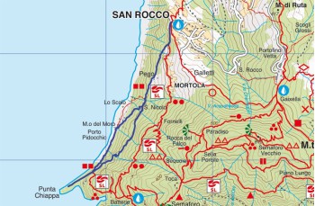
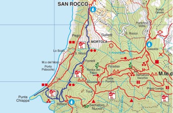
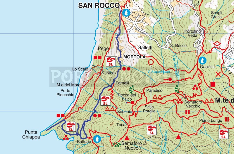
Here, we propose a fascinating route that descends among the military positions built by the Germans during World War II and reaches Punta Chiappa. Originally constructed in 1941 to transport materials needed for the construction of the 202nd Punta Chiappa Battery via a rail system, the trail was neglected after World War II, and vegetation took over.
In 2015, as part of a redevelopment and enhancement project for the entire area, the trail was restored and renamed "Sentiero Hans Hill," in memory of the German soldier who wrote a diary during his time in this place during the war.
The starting point for our walk is San Rocco di Camogli, which can be reached by private vehicle (please remember to park before the barrier that limits access to residents only), by bus, or on foot from Camogli.
Upon reaching the church square of San Rocco, a splendid panoramic terrace overlooking the Gulf of Paradiso, continue along the path that runs along the sea. After a few minutes, beyond a first path that descends to Punta Chiappa (via San Niccolò), you'll pass through the locality of Mortola, a very characteristic small cluster of houses.
Once past the hamlet, you'll encounter a few more houses and, on the left, a source of drinking water. Then, the trail enters the forest and, after about 20 minutes, arrives at the locality of Fornelli, where you should continue straight. Following a stretch on level ground, there are some ups and downs on irregular but easily passable rock steps and a short uphill section that leads you out of the undergrowth to a highly panoramic point.
After about 40 minutes from the start, you'll arrive at the locality of Groppo Marso, where you'll encounter the first deviation for Punta Chiappa. This trail merges with the one we have chosen and that you'll find, well-marked, a bit further ahead in the locality of Batterie.
Here, you'll find the "Silvio Somazzi Visitor Center".
After passing the first gun emplacements, you'll encounter a series of deviations that lead to "war artifacts." Continue to the left on the beaten path, always following the signs for Punta Chiappa, the rocky promontory that emerges majestically from the sea.
Almost the entire route consists of sometimes slightly high and rudimentary steps, which, along with the chain, facilitate the descent and prevent slipping.
After passing the second position, the trail ascends to merge with the path coming from Groppo Marso, and by continuing to the left, you'll arrive near the bunker that is clearly visible from the sea amidst the vegetation.
Always keep to the left to descend through a forest that offers some beautiful glimpses of Camogli. After passing an old Enel cabin, a short level stretch precedes the wooden staircase that marks the end of your itinerary, between Punta Chiappa to the left and Porto Pidocchio to the right.
Here the path traced by the GPS
Here the path traced by the GPS
Unlock, view and download the gpx track by becoming a Supporter.
Data sheet
You might also be interested in
| Difficulty | Medium |
| Duration | 1h |
| Length Km | 3,000 |
| Footpath signs | |