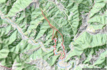
This classic loop trail ascends Monte Ramaceto, starting from Passo di Romaggi (or Pozza dei Lupi). You can reach it from Carasco, just 10 minutes by car from the Lavagna highway exit. There are two routes: via the Val Fontanabuona road, ascending from San Colombano Certenoli to Romaggi and then to the pass; or via the 586 Val D’Aveto road, turning left at Terrarossa to reach Cichero and then the pass.
There are no water sources along the trail, so bring enough water. Park near the main signboard and take the left path, which gently ascends into the woods marked by FIE trail signs  . This is also the Path of the 7 Steps
  starting from Carasco.
Once out of the woods, the trail offers stunning views of the surrounding peaks. At a junction, ignore the left path to Monte Mignago (a 15-minute climb) and continue straight. The terrain becomes rocky as you ascend to Passo del Dente, where it joins the path from Costa di Soglio. Cross an area with large stone slabs.
At the next junction at Pian dei Baci, leave the and turn right to start the steep climb to the summit, following the trail marker .
After a wooded section, the ascent remains steep but rewards with beautiful landscapes. The trail winds through grassy terrain, summer pastures, and some rocky patches.
Trail markers can be hard to spot, so stay alert.
After a brief rocky section, and about 2 hours and 15 minutes from the start, you'll reach the small chapel on Monte Ramaceto (1320 m). It can provide shelter in sudden bad weather.
The summit view is worth the effort, so plan for a clear day.
Leaving the chapel, follow the Alta Via dei Monti Liguri signs to begin an exciting descent westward along a panoramic grassy ridge. After about 20 minutes, you'll reach Bocca di Feia, a crossroads offering various paths.
Continue left to descend and reconnect, after about 500 meters, with the 7 Passi itinerary.
At the intersection, head left on a pleasant, mostly flat 2.4 km trail surrounded by ferns, which can be dense in summer.
Cross occasional streams and a viewpoint with a bench, returning to Pian dei Baci at the junction from the ascent, now on your left.
Retrace your steps to return to Passo di Romaggi, where the trail ends.