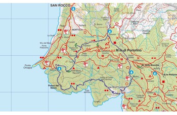
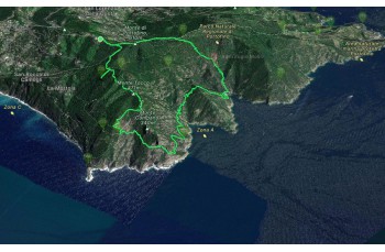
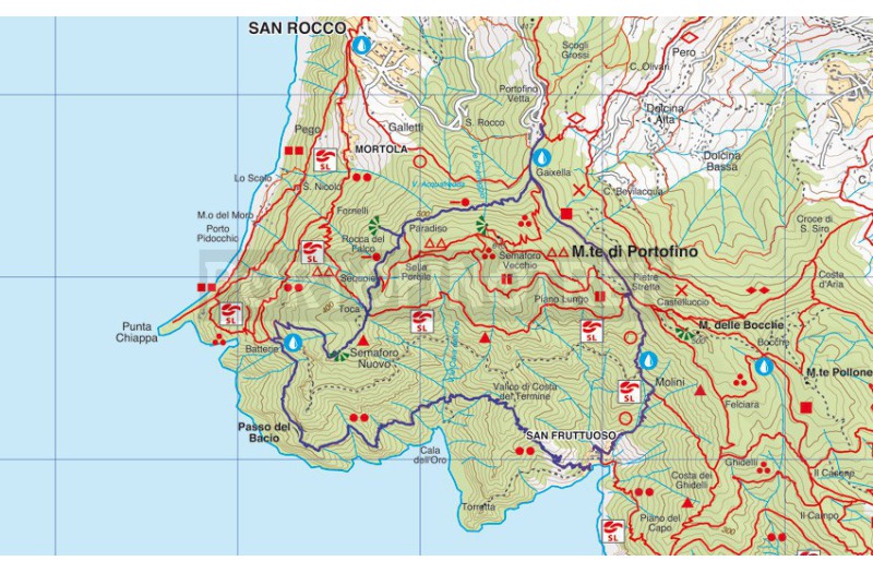
Portofino Vetta - San Fruttuoso - Passo del bacio - Batterie - Semaforo Nuovo

  • San Fruttuoso di Camogli, Monte Parco di Portofino
  • Cala dell'oro, Punta Torretta, parco di Portofino
  • Semaforo Nuovo, Parco di Portofino
Difficolty High
Duration 4h 45'
Length Km 10,900
Footpath signs   + + + triangolo.png +
Dislivello 3m - 528m | dislivello positivo 961m | dislivello positivo 962m
PartenzaStarting point
Passing through

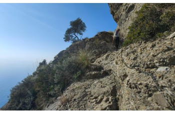
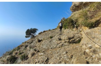
This trail, which allows you to discover the paths and the most panoramic points of the Portofino Park. A part of it is classified EE and requires adequate athletic training due to the duration, height differences, and the passages equipped with chains..

It is also recommended that:
- wear trekking shoes
- bring a good amount of water
- avoid the hottest and sunniest days.

The departure is in Portofino Vetta, where it is possible to park cars and scooters for free in the area preceding the arrival at the Kulm hotel. Right in front of it is the access to the Park, which in a few meters leads to the main path, which you have to follow to the right, ignoring the detours you come across, thus arriving at Gaixella, where there is a drinking water tap and a table with wooden benches.
Continuing straight on, you will soon reach another rest area at Pietre Strette, considered the fulcrum of Monte di Portofino due to the numerous paths that cross it.

Keep to the right to pass between the imposing conglomerate boulders and continue on the well-signposted path that descends to San Fruttuoso di Camogli, an entirely downhill path, initially shaded by trees and made up of a series of hairpin bends.
After about 20 minutes you leave the wood and reach Caselle where there is a drinking water tap, and shortly after an old mill, now restored and used as an agritourism, where it is possible to sleep or stop for lunch (check opening days).

From here, sunny stretches alternate between cultivated strips and shadier stretches that run alongside a small stream, where you often come across wild goats, up to the sixteenth-century Doria Tower. Following the path to the right, you will pass behind the majestic Abbey of San Fruttuoso and descend into the heart of the enchanting village (here there is a tap for drinking water)
The route is still long but those who have some time available can make a detour to the beach by going down the ladder near the entrance to the church. Otherwise, continue going up to the right and follow the track that leads above the landing stage (there are also some public toilets here).

Now the climb begins and in about 30 minutes, crossing a beautiful wood characterized by some specimens of centuries-old maritime pines, it leads to the pass of Costa del Termine from which you descend, on the Cala dell'Oro side, along a steep path (pay attention because it can be slippery) that proceeds in a typical Mediterranean scrub environment.
When you get close to a small chain, which delimits the path, the most spectacular stretch of the itinerary begins: a narrow path overlooking the sea runs along the western side of the promontory, with some ups and downs on the rock and exposed passages equipped with chains.
In about an hour you reach the renowned and panoramic Passo del Bacio.

You will soon arrive at Batterie, characterized by the Battery Visitor Center which is worth a stop to admire the landscape, the war artifacts and take advantage of stocking up on water from the drinking water tap .
To follow our route, go back a few steps to take the path, marked with the FIE trail marker. semaforo nuovo, which in about 20 minutes goes up to Semaforo Nuovo, another position with a view that embraces from Capo Mele to Tino island.

In 5 minutes you arrive in Toca, the intersection point of various paths, where you must follow the wide flat path, signposted by segnavia FIE, which continues in the woods up to Paradiso, where above you can see a building that is now abandoned, but used as a refuge until some time ago. Before continuing, it is advisable to go down to the left to arrive, in a few minutes, at the small panoramic balcony called Rocca del Falco.

Returning to the main path, the descent begins which in about 20 minutes leads back to Gaixella and therefore to the starting point of this itinerary.


Unlock, view and download the trail track by purchasing a map.

The path tracked tracciato by GPS

Data sheet

Time
From 4h to 5h
Length Km
10 - 15
Difficulty
High

Download

Unlock this feature by purchasing our map

Trail ring from Portofino Vetta to S. Fruttuoso, Passo del bacio, Batterie and Semaforo Nuovo.

100% secure payments