• Out-of-Stock

Rapallo - Sant' Ambrogio - Monte Castello - Rapallo

  • Rapallo - San Bernardo - Monte Castello - Sant' Ambrogio - Rapallo
  • Salita al Pianello
  • Sentiero verso San Bernardo
  • Bivio vecchia chiesa di S. Bernardo
  • Monte Castello
  • Sant'Ambrogio
Difficulty Medium
Duration 3h 45'
Length Km. 8,900
Footpath signs segnavia + Rombo
Dislivello 8m - 653m | dislivello positivo 809m | dislivello positivo 814m
StartStarting point

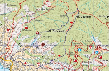
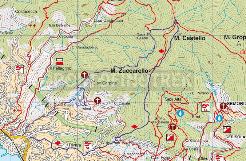
This route allows us to reach Monte Castello from Rapallo in about 4,3km with a drop of just over 600 meters with a path constantly straddling the borders of Rapallo and Zoagli.

The starting point is in the locality of S. Rocco, near the small church of the same name.
In front of the Bar Aurelia begins Via al Pianello, a fairly demanding staircase which, after having crossed Via San Rocco , after about 500 meters it takes us to Via Carcassoni . We continue to the right for about 10 meters and immediately take the stairway to the left continuing to climb. This staircase opens up splendid views over Rapallo and the entire Gulf up to the promontory of Portofino; we follow it for about 900 meters, always continuing to climb until we cross Via S. Bernardo.
We rest for a while, catching our breath, enjoying the view before taking the paved driveway to the right for about 50 meters, here, on the left, we begin to climb again along a staircase that takes us right under the main street which still has the name of Via San Bernardo .

Here we continue to the left on a path that continues between ups and downs for about 300 meters crossing a small stream to a crossroads; here we go up again right next to a wall that delimits a private property up to the ruin of the ancient chapel of San Bernardo .

We continue leaving behind what remains of the dome of the chapel, following the path marked with a red and a white line at the time of writing.
We follow this signpost, even if it is impossible to go wrong, the path is one and continues in pleasant way, always continuing to climb, crossing holm oaks and chestnut woods, always looking left at the Sanctuary of Montallegro.

After about 1.5 km, a series of very wide "bands" heralds the beginning of the ancient settlement of "Case di Besain", an old group of cottages that have been abandoned for many years. Here the path crosses the one marked with 3 in line circles (3 cerchi rossi) that comes from Casette locality (and even earlier from the Tuja Valley). We walk all the way up and after about 10/15 minutes we find ourselves on the slopes of Monte Castello connecting to the ridge path that on the left leads to Montallegro and on the right it forks, offering the possibility to go down to Sant 'Ambrogio (on the right) or towards Chiavari (on the left).

In the middle of this fork we see the indication that in a few meters takes us to the top of Monte Castello .

A regenerating break is deserved.

It is impossible not to notice the reconstruction of the plan of the very ancient "Castrum Rapallinum" built between the 14th and 15th centuries and brought to light during the archaeological excavations which took place from 1997 to 2001.
From here you have a very wide view of the mountains of the hinterland, from the nearby Ramaceto, to Monte Caucaso, to Monte Porcile and to the gulf from Sestri Levante (from the Cinque Terre on clear days) to Genoa and beyond; the view is truly stunning.

We begin the descent by taking the path that walks along the ridge line Monte Castello - Monte Zuccarello until we reach the marker post of the Municipality of Zoagli which indicates the direction for Sant 'Ambrogio. Immediately on the left we find a votive chapel, from here we continue to descend now following the red rhombus path diamond.

After about 45 minutes walking in the woods, we cross the driveway of Forno Vallette . We continue to descend taking the staircase in front until we reach the side of the small church of S. Isidoro and after 100 meters on the churchyard of the church of S. Ambrogio . Here we also find a drinking water tap.

To go down to Rapallo we take the staircase in front of the church, turning right after a few meters and, passing through fields and private houses, we arrive in Via Pietrafraccia about 100 meters from the starting point.

Unlock, view and download the trail track by purchasing a map.

GPS path on Google Maps

Data sheet

Time
From 3h to 4h
Length Km
8 - 10
Difficulty
Medium

Download

Unlock this feature by purchasing our map

Rapallo - San Bernardo - Monte Castello - Sant' Ambrogio - Rapallo

100% secure payments