- Out-of-Stock
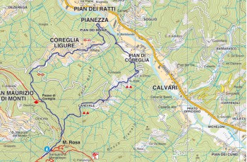
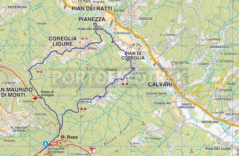
Circular route of Coreglia from Montallegro


| Difficulty | Medium |
| Duration | 3h 45' |
| Length Km | 9,200 |
| Footpath signs | |
What we propose here is known as the Ring of Coreglia , an itinerary that also includes some passages on a paved road but still surrounded by greenery and not at all trafficked by cars or motorcycles.
For the many. passages in the woods this is a recommended itinerary also in summer, remembering however to bring a good supply of water.
The departure is from Montallegro which can be easily reached from Rapallo with your own car or motorbike, by bus, with the overview cableway or by feet, along the ancient mule track .
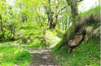
Starting from the square, go up to the Sanctuary and continue to the left, on the shady path on a false floor, until you meet a wooden CAI sign that marks the path to Canevale - Pian dei Ratti , also known as Giovanni Chichizola Path , in memory of the farmer who witnessed the apparition of the Madonna here in 1557.
As soon as you enter the path you can see a curious plaque dedicated to the Queirolo cousins that until the 1980s on weekends they organized an "open-air" tavern for hikers and pilgrims.
The path is well marked by F.I.E. with ![]()
![]() , is very pleasant and it has no particular difficulty; a wide and shady path that gradually loses altitude and, in about 45 minutes, comes out above the church of Canevale .
, is very pleasant and it has no particular difficulty; a wide and shady path that gradually loses altitude and, in about 45 minutes, comes out above the church of Canevale .
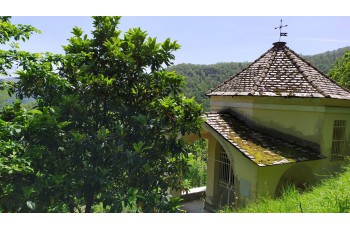
Here you go down to the church square and continue on the cemented staircase which passes next to some houses and joins the paved road that you have to follow on the left, passing by the Cappella delle Grazie and Casa di Chichizola, for about 450 meters until on a curve that turns to the right, you meet two signposts on the left that lead back to the path, hardly visible if there is tall grass.
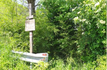
The path soon leads back to the driveway, which in any case is very quiet and surrounded by greenery, crossing Case Arditi, a small group of rural houses. After passing a large and fascinating abandoned house, in Ca 'di Crovo you can see on the left a wooden panel and the signs ![]()
![]() on the guard rail indicate the path to follow, otherwise not so visible.
on the guard rail indicate the path to follow, otherwise not so visible.
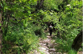
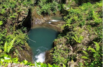
The path now crosses a wetter area in the woods and, after having skirted a fenced area, the increasingly intense sound of the flowing water anticipates the arrival at a medieval stone bridge, which invites you to stop for a moment; continuing straight ahead, in a few meters, you will rejoin the asphalted road which you must follow to the left.
At the junction at Piani di Coreglia , continue straight on the Ciclovia dell'ardesia until you reach Pian dei Manzi in front of the small town hall of Coreglia Ligure , where some sculptures made by Berzsenyl Balàzs have been placed .
Here the uphill on the left of the Town hall starts, signed by ![]()
![]() even if not always so visible.
even if not always so visible.
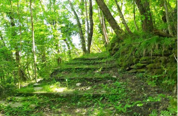
Climbing the wide cobbled steps that become a pleasant mule track initially crosses the wood then climbing in a fairly gentle way, along more open and sunny stretches to come out, after passing by some houses and an ancient chapel, on an asphalted road that you cross to find the path that follows without problems through a picturesque village, up to a retirement home for the elderly where you meet a crossroads that could create some doubts about the right direction to follow: continue straight, the grass during Spring and Summer is very high and the path cannot be seen so well, on the right there is a bed base set up as a gate but it is not clear whether it delimits a private property or serves only to prevent the passage of wild boars: go straight.
We find the trail sign near some houses where we cross the driveway again to go up the mule track which climbs through the countryside and leads to Via Perini, where you continue left to the end and then continue on a stairway to the right that takes us, for the last time, to cross the driveway.
Taking the stairway with wide and low concrete steps you find yourself on a grassy path that climbs between fields and trees of hazelnuts to cross immediately after a more humid environment as evidenced by the stones covered with moss, thus arriving at the Passo di Coreglia where you cross the path that connects the Sanctuary of Montallegro to the Passo della Crocetta .
From here, walking flat to the left, you will reach the starting point in about 20 minutes, thus closing the loop.
Unlock, view and download the gpx track by becoming a Supporter.
Data sheet
| Difficulty | Medium |
| Duration | 3h 45' |
| Length Km | 9,200 |
| Footpath signs | |