- Out-of-Stock
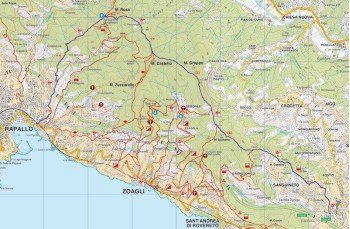
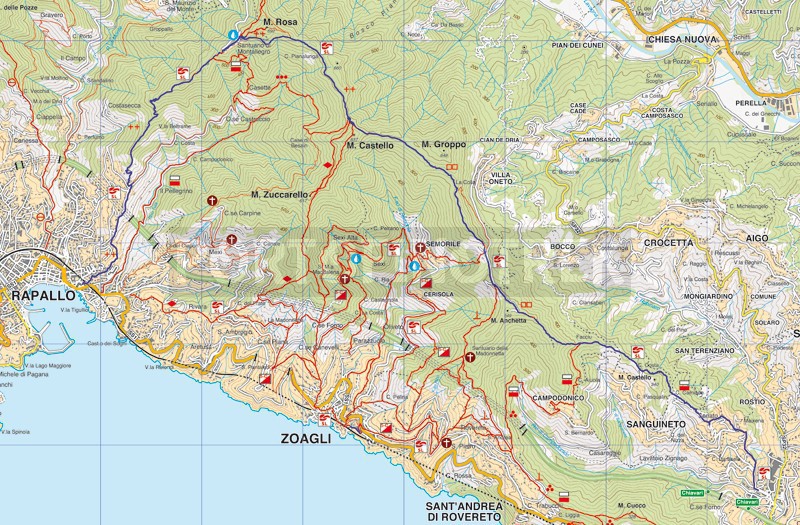
Rapallo - Montallegro - Chiavari


| Difficulty | Medium |
| Duration | 4h 30' |
| Length Km | 12,200 |
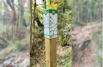
| Footpath signs | |
A pleasant excursion that can be traveled in the summer because it develops, in large part, in the woods. We recommend starting equipped with a sufficient amount of water because the few sources that are encountered are dry (in summer), except for the one behind the Sanctuary of Montallegro. The route can also be started from Montallegro that you can reach in a few minutes by cableway.
The starting point is the Church of San Francesco, on Via S. Francesco d'Assisi (close to the old castle).
Take the wide staircase to the left of the church, rising through the houses to emerge in Via Don Minzoni, turn left and follow the road for about 500 meters until you see, on the right, a shortcut (a stone staircase) that lead in the church of San Bartolomeo.
Reach the church and finally abandoned the driveway and continue along the old mule track.
Accompanied by the "sound" of the highway, climb along the cobbled path that climbs between dry stone walls and sides, with a view of St. Ambrogio and the entire surrounding valley.
Omit the only deviation that will show up on your right and continue straight on to meet a private chapel and reach a small group of houses in the village Pellegrino.
Go to the left the road for about 50 meters, to take the trail to the right, which now increases the slope.
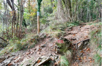
The path continues, winding alternating stretches< more shaded in the woods at times more open (and very sunny in the summer).
Along the way a stone in yellow shows you halfway between Rapallo and Montallegro followed by a small stone cottage, only shelter in case of a sudden storm.
A short stretch of mostly flat (but slippery in particularly wet) with a view of San Maurizio Monti, anticipates a series of steps leading to the cableway station. From here, continue on the main avenue that reaches the foot of the stairway of the Montallegro Sanctuary.
Go around the majestic sanctuary and turn right, following the two empty squares, to continue on the path that a slight slope, past a hotel and restaurant with tables in a panoramic position, enters a fresh woods. Reached a crossroads, continue left (right and go to St. Ambrogio) the narrow path that overlooks the Fontanabuona Valley (in summer the view is a bit 'covered by vegetation). Along the way, meet, right, the symbol of a source that we, in August, we found completely dry.
With a series of ups and downs of boulders out of the woods to cross a stretch more open and covered with tall grass that dominates Zoagli and the promontory of Portofino. In this section, you can see many rustic abandoned, indicating that this area was once inhabited by farmers.
Once in front of a small votive shrine, in Passo la Colla, go right to trace gently sloping Monte Anchetta which soon descend to meet a paved road to the Passo dell' Anchetta.
Stay on the paved road that goes through the woods and reach the plain near the restaurant Il Galletto to admire the view, then continue on the paved road until you come to a curve to the right. Here take the narrow path on the left that goes down into the woods, where you can see curious succession of stone slabs, probably used to mark the borders. After a few meters you come to a fork in the road, here you have to continue to the left.
The route is all downhill on a trail of dirt and stone and passes a small meadow with a nice wooden hut that has a generous private made available to hikers and can serve as a shelter in case of sudden tunderstorms.
Shortly after trail sign ![]() add
add ![]() and together we lead at Case Costa, where you will find a small chapel and some old stone houses. A particularly clean stretch follows from which you can enjoy wonderful views on your left of the hamlet of Leivi, and of Chiavari and the Gulf, on the right.
and together we lead at Case Costa, where you will find a small chapel and some old stone houses. A particularly clean stretch follows from which you can enjoy wonderful views on your left of the hamlet of Leivi, and of Chiavari and the Gulf, on the right.
After a few meters, at the fork, follow on the right the signs to Chiavari; it is a short stone staircase which then continues with a path which advances between cultivated terraces, surrounded by olive and fig trees. At the next fork, keep left and follow the two lines (white and red), until you get behind the Maixena cemetery and the Maixena church.
From here go down on staircase on the left side of the church passing between the houses and leads you to Sampierdicanne, where our journey ends.
From Sampierdicanne you can reach the heart of Chiavari by feet (about 25 minutes) or by bus (check timetable on AMT website).
Unlock, view and download the gpx track by becoming a Supporter.
Data sheet
| Difficulty | Medium |
| Duration | 4h 30' |
| Length Km | 12,200 |
| Footpath signs | |