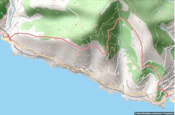
This trail starts in the seaside village of Sori, climbs up the hill, and follows scenic paths down to Recco.
Begin at Piazza della Chiesa, to the right of the Santa Margherita parish. A climb leads you to Via Aurelia, emerging near a traffic light.
Cross the road and pass the church of San Rocco. Take the stone staircase, which is steep and challenging, following the trail marker  . After about 300 meters, the staircase ends and turns into a steep road leading to the Church of S. Apollinare, offering a stunning view.
Continue right on Via Belvedere to reach Traliccio  and then Pineta Polanesi. This stretch is particularly scenic. Enter the woods and arrive near two old rainwater tanks at Vasche di Ageno, then shortly after at Ageno nord.
The path flattens out, passing some beautiful houses, until "Pin du cè tu". Here, begin the descent to Ageno Piazzetta, a road with a bus stop.
Cross the road and take Salita della Giudea for just over 150 meters. At the signpost, turn left to reach Megli, a Recco hamlet known for its focaccette festival, right in front of the churchyard.
Descend following the trail marker  . Cross the road, pass by the cemetery, and reach a small chapel where you turn left. After about 300 meters, you arrive at Via Aurelia near a traffic light. Cross the road and head downhill to the seaside promenade, where the trail ends.
The trail overlaps some sections of the Sentiero Liguria, marked with trail signs  or
or  .
.