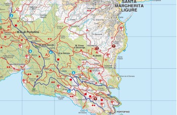
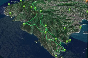
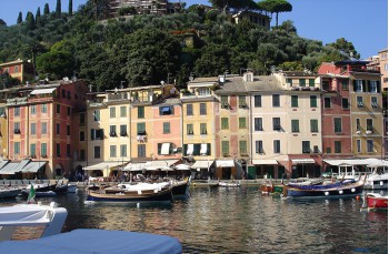
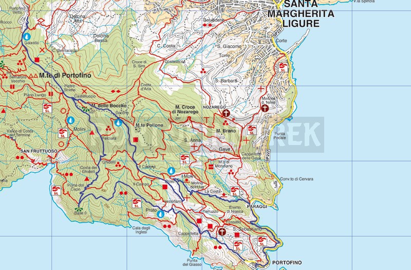
Portofino Vetta - Base 0- Portofino - Paraggi - Olmi - Portofino Vetta

Difficulty | Medium |
Duration | 4h 30' |
Length km. | 15,000 |
Footpath signs | ![]() ![]() ![]() ![]() |
![]() ![]() ![]() | |
![]() |
After parking your car in the square on the right, shortly after the pretty stone church of Portofino Vetta (420 meters above sea level), you can choose whether to enter the park via the 'entrance in front of the car park or continue for about 300 meters on the carriage road until the second access to the paths, behind the hotel.
Both entrances come together on the same path that moves almost entirely in the plain, passing under the TV antennas and passing through Gaixella (412mt. asl), a small area and crossroads of many paths (Semaforo nuovo, Semaforo Vecchio, San Rocco), equipped with benches, wooden tables and a drinking water faucet.
The path continues maintaining the wide shaded path which, in short and without difficulty, arrives at Pietre Strette (464 meters above sea level), considered the center of Mount Portofino. There is another drinking water faucet.
Here continue straight for a few meters until the first deviation on the right indicating Base 0.
The path follows the ridge of the mountain and has many panoramic points and advances on a slight slope up to Felciara (436mt a.s.l.), an open space in the middle of ferns equipped with wooden tables and benches.
Briefly, you will find Ghidelli (393mt above sea level), from which there is also a connection to the path that leads to Portofino mare, and Costa dei Ghidelli , from which starts a small connection that reaches the Agririfugio Molini and San Fruttuoso.
The journey now proceeds downhill and arrives at Base 0 (220mt above sea level), where you will find a wooden table and benches. Here you can take a few minutes of break on the small terrace overlooking the sea that you find behind the rock. To continue, keeping your back to the rock, take the path to the right (to the left you go down to San Fruttuoso di Camogli) on a very scenic path which alternates short flat stretches with numerous ups and downs between protruding rocks.
The path (very sunny in summer) is completely overlooking the sea with incredible views of the bays below.
Once you reach a small group of houses called "Prato" you enter a short but steep driveway that ends in the middle of chestnut trees; continue now on a narrow and flat path that passes above Cala degli Inglesi (reachable with a slightly demanding path) and arrives at Cappelletta , so called for the presence of a small chapel.
After passing a gate installed to prevent the passage of wild animals, the path is all downhill and leads to via Fondaco, and then to the Portofino car park.
After an obligatory visit to the famous village, the journey resumes, at the church of San Martino, with the pedestrian Portofino-Paraggi, a beautiful walk in the green that offers various panoramic views.
Once in Paraggi, enter the car park and at the end take " Via dei Mulini ". The path begins with a concrete staircase and continues through a shady valley passing by the remains of some old mills (all explained through descriptive panels) and ends under the restaurant Mulino della Gassetta
Turning left you will reach Olmi (250 meters above sea level) and take the main route that connects Portofino Mare to Portofino Vetta; the path on the right, wide and well kept, goes straight up among chestnut trees, pines, holm oaks passing through Crocetta (363 m asl) , where you can rest on some shady benches, and localities Bocche (454mt. slm), another stopping point also equipped with tables and drinking water tap.
In 15 minutes from here you will find yourself again in Pietre Strette and therefore, following the route of the outward journey, the itinerary ends in the car park of Portofino Vetta.
Unlock, view and download the trail track by purchasing a map.
Data sheet