- Out-of-Stock
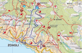
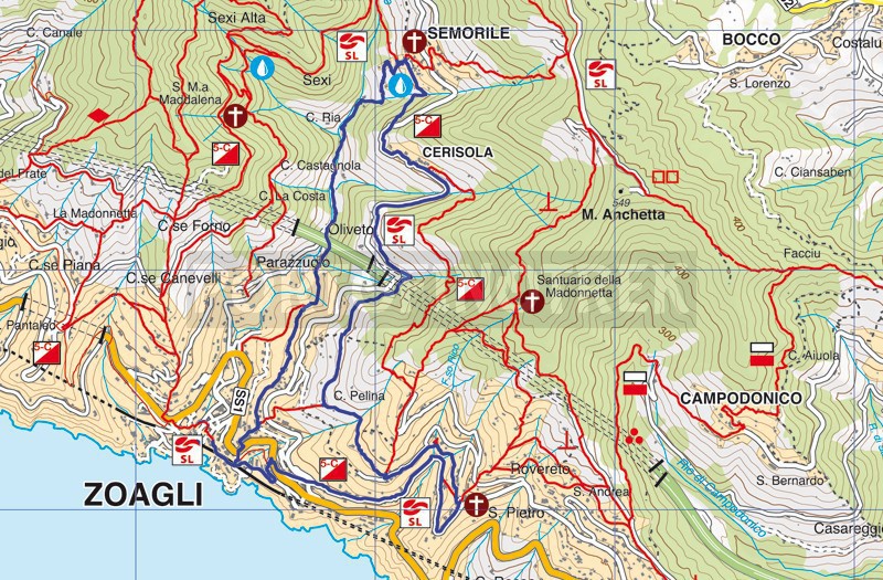
Zoagli - Semorile - San Pietro di Rovereto - Zoagli


| Difficulty | Easy |
| Duration | 3h |
| Length km. | 8,200 |
| Footpath signs | |
This itinerary is developed mainly along paths and Creuze, with some sections (especially the end) of the driveway cute anyway because quiet and scenic.
The walk starts at the small square of Zoagli, with Via Garibaldi, the steps that you find next to the pharmacy, and that, passing near the track takes you on the Via Aurelia (if you arrive, however, by train, out of the station, turn left and then to the right).
Here, walk a few meters to the right, then cross the road and take Via Castello, a path up through the house, and after crossing the paved road continues mostly flat, first through the campaign and then the woods. Ignore the deviations to the right you meet along the path and mantene always left to pass under the motorway bridge and continue along Via dei Mulini ![]() .
.
The trail then passes under some of the houses and along the stream Semorile, begins to rise. The natural beauty of this part of the path is added a curious exposure to "open" the original sculptures arranged around a private home.
Walking among chestnut and olive trees with a final "tear" finale arrived in the churchyard of the Church of Semorile which is located in the town center (about 1h from Zoagli).
After a well deserved break to enjoy the peace that reigns in the small village, retrace a few meters of the stairs you came to immediately turn left following the signs for Cerisola.
From this point, follow the contrary, the trail of the path of the "5 campanili" ![]() . Follow the road that passes under the cemetery until it meets after a steep climb that takes you to a magnificent viewpoint, the left fork for Cerisola.
. Follow the road that passes under the cemetery until it meets after a steep climb that takes you to a magnificent viewpoint, the left fork for Cerisola.
Cross the small group of houses, which gathers around the church yellow and back down through a stone bridge, on the road.
After about 200 meters abandon it again to take on the left, Via Dei Frantoi, in the locality of Oliveto. The concrete path through another small village and then turn into the path of the earth and go first between age and dry stone walls and then into the woods.
After a ride on the highway you are at a crossroads, take the left path uphill through a tract of land particularly bleak and stony, but from which there is a 'good view of the Gulf of Tigullio.
Now meet some deviations that can be misleading, but make no mistake, follow the origin of the white arrow (with the tip facing you) followed by the symbol 5C. Once on a driveway, go straight for about 50 meters to the left and then continue on the road smallest, to the right, which leads to the church of San Pietro di Rovereto.
From there, just follow the road that, right through St. Peter and down to the sea, offering spectacular views of the coast. After few along the way a sign on the left indicates a "panoramic point".
Once at the bottom with a short pedestrian left you are on the Via Aurelia. Continue to the right for a few meters until you reach a road on the left leads down to the station of Zoagli, where your journey ends.
Unlock, view and download the gpx track by becoming a Supporter.
Data sheet
You might also be interested in
| Difficulty | Easy |
| Duration | 3h |
| Length km. | 8,200 |
| Footpath signs | |
