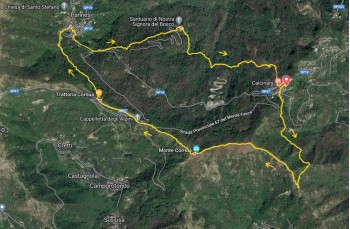
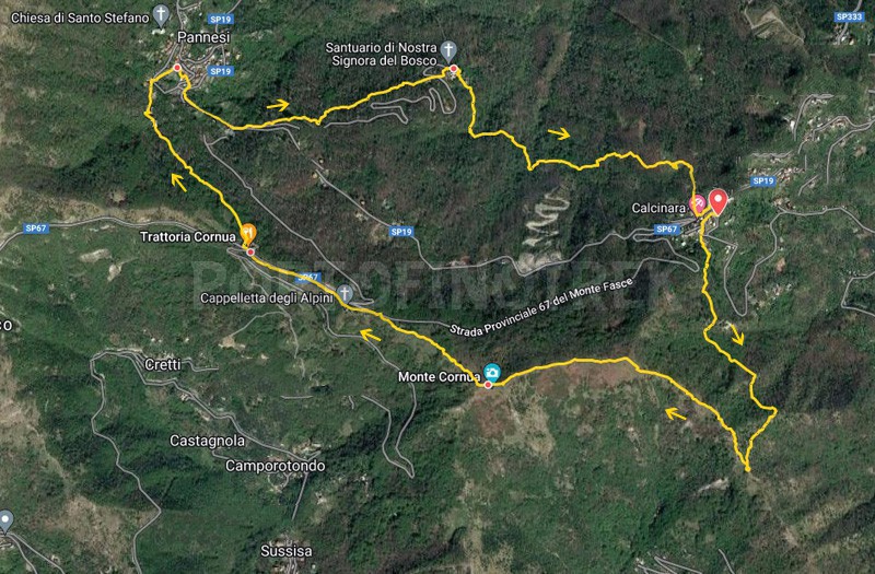
Circular trail from Calcinara - Monte Cornua - Pannesi - NS del Bosco

| Difficulty | Low |
| Duration | 2h 20' |
| Length km. | 7,600 |
| Footpath sign | |
Calcinara is a small hamlet of Uscio, located about 12 kilometers away from the coastal town of Recco.
The route we suggest is a mildly challenging loop that can also be covered during the summer due to the numerous stretches through the woods. There isn't an actual parking lot, but there are opportunities to park along the road.
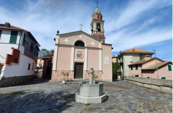
The starting point is located below the Church of Our Lady of Caravaggio, where the FIE trail marker of the Historic Colombian Itinerary is clearly visible. (![]() ). Follow this marker to cross the church square, then proceed among the houses and eventually encounter the trail. Continue immediately on the path marked with
). Follow this marker to cross the church square, then proceed among the houses and eventually encounter the trail. Continue immediately on the path marked with ![]() , proceeding through the woods and gradually ascending until you reach the ridge at a junction. The path to the left leads towards Mount del Pré, while going straight takes you down towards Testana.; On this route, you turn right and begin to ascend following the trail marker IS1, crossing through a more open terrain where, during certain times of the year, you may encounter tall grass.
, proceeding through the woods and gradually ascending until you reach the ridge at a junction. The path to the left leads towards Mount del Pré, while going straight takes you down towards Testana.; On this route, you turn right and begin to ascend following the trail marker IS1, crossing through a more open terrain where, during certain times of the year, you may encounter tall grass.
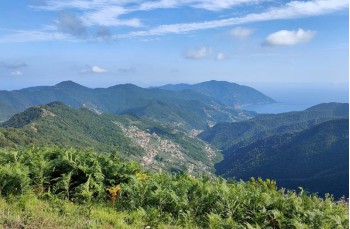
A rest area with wooden tables and benches precedes the final uphill stretch that leads directly to the summit of Mount Cornua (687 meters above sea level), from which you can enjoy a spectacular view of the Gulf of Paradiso.
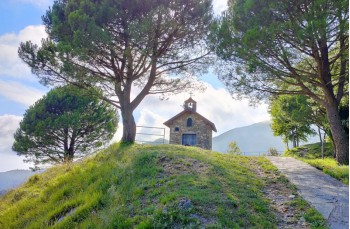
Continuing straight ahead, you descend onto the provincial road that leads towards Monte Fasce, and you follow it to the left for a short distance until you spot, still on the left, the Alpini Chapel, a small stone building situated on a panoramic hill. Follow the path that passes above the chapel to find yourself, shortly thereafter, back on the Provincial road, at the location of Case Cornua, near the bar/restaurant.
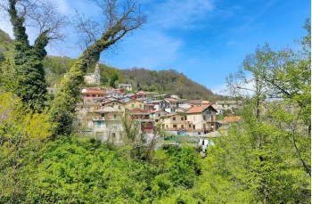
To resume the trail, marked with the ![]() trail marker, you need to pass in front of the entrance of the establishment and immediately turn right to descend. Now the path is entirely shaded by a beautiful forest until you reach the first houses of the Pannesi locality, a small village in the Municipality of Lumarzo. You will pass by some washbasins (where you can also find a drinking water tap) and continue on to reach the drivable road.
trail marker, you need to pass in front of the entrance of the establishment and immediately turn right to descend. Now the path is entirely shaded by a beautiful forest until you reach the first houses of the Pannesi locality, a small village in the Municipality of Lumarzo. You will pass by some washbasins (where you can also find a drinking water tap) and continue on to reach the drivable road.
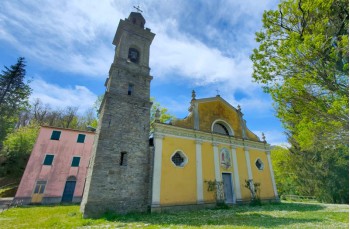
You walk along the asphalt road for about 300 meters until you find, on the left after passing a trattoria, another asphalt road that descends. Immediately below to the left, you'll see the trail that leads into the woods. After crossing an area designated as a rest stop, with wooden tables and benches, you emerge behind the Sanctuary of Our Lady of the Woods, a Marian sanctuary with an attached characteristic stone bell tower.
From the church square, you resume the trail indicated in the direction of “Colle Caprile”, which enters the woods and proceeds with some ups and downs. After a little less than a kilometer, you leave the main trail and, paying attention, you need to identify (it's not marked) a path that ascends to the right. In about 10 minutes, it will bring you back to Calcinara, to the starting point.
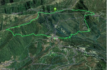
The path tracked on Google Maps
Unlock, view and download the gpx track by becoming a Supporter.
Data sheet
| Difficulty | Low |
| Duration | 2h 20' |
| Length km. | 7,600 |
| Footpath sign | |