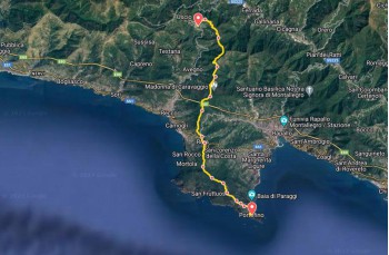
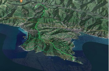
Trail from Uscio to Portofino.
  • Trail from Uscio to Portofino.
  • Trail from Uscio to Portofino.
  • Trail from Uscio to Portofino.
  • Trail from Uscio to Portofino. Available with Supporter
  • Passo della Spinarola Available with Supporter
  • Trail from Uscio to Portofino. Available with Supporter
  • Trail from Uscio to Portofino. Available with Supporter
  • Trail from Uscio to Portofino. Available with Supporter
  • Trail from Uscio to Portofino. Available with Supporter
  • Trail from Uscio to Portofino. Available with Supporter
  • Trail from Uscio to Portofino. Available with Supporter
  • Trail from Uscio to Portofino. Available with Supporter
  • Trail from Uscio to Portofino. Available with Supporter
  • Trail from Uscio to Portofino. Available with Supporter
  • Trail from Uscio to Portofino. Available with Supporter
  • Trail from Uscio to Portofino. Available with Supporter
  • Trail from Uscio to Portofino. Available with Supporter
  • Trail from Uscio to Portofino. Available with Supporter
  • Trail from Uscio to Portofino. Available with Supporter
  • Trail from Uscio to Portofino. Available with Supporter
  • Trail from Uscio to Portofino. Available with Supporter
  • Trail from Uscio to Portofino. Available with Supporter
Difficulty Easy
Duration 5h 00m
Distance 17,500
Trail marker Due cerchi vuoti + Quadrato
Starting point Uscio

Trail effort

Shows the overall physical effort required by the route, not the technical difficulty of the trail.

Supporter

With Supporter, you can view the real trail effort.

Supporter

Route profile

Use the trail on the go

Open the trail on your phone or download the file to use it during your hike.

Open Google Maps Supporter Download GPX Supporter Download PDF Supporter+
3D route animation Supporter+
  • Interactive map
  • Synced elevation profile
  • GPX
  • Key waypoints
  • Planning tools

Unlock the complete trail features

With Supporter+, you unlock the interactive map, synced elevation profile, GPX, key waypoints and a more useful trail view.

Begin your hike in Uscio, right in front of the Sant’Ambrogio church. Head left onto Via Costa Chiesa, leading you to Via Bisagno. Turn right here to find the trailhead at the start of Via Arnaldi.

The trail is a mule track that climbs through a chestnut forest. It passes a small cluster of houses before reaching Passo Casetti, marked by a wooden bridge and a votive shrine. Cross the bridge and follow the FIE trail marker Due cerchi vuoti. This easy 1.7 km walk bypasses the ascent to Monte Tugio and leads to Passo della Spinarola.

Cross the bridge over the road connecting Uscio to Tribogna and Fontanabuona, then continue through the forest. The trail is pleasant and mostly flat. About 5 km from the start, you'll reach the "slopes of Monte Bello." Follow the same trail marker to Passo del Gallo, an open area with views of Golfo Paradiso, grassy meadows, and wooden benches and tables. Continue straight, and at Colle del Gallo, keep right, ignoring the left turn to Monte Orsena and Caravaggio Sanctuary.

At Piane di Caravaggio, the trail merges with one from Monte Orsena. It leads to Pian di Cren and then descends for about 2 km to Chiesa Millenaria di Ruta di Camogli.

Here, follow the provincial road for about 400 meters towards Ruta, then turn left onto Via Romana, passing the Church of San Michele Arcangelo di Ruta. Ascend a few meters to the left (a drinking water tap is on the right) to reach the trailhead for Portofino Vetta, marked by the trail marker Quadrato. This main trail crosses Mount Portofino from Ruta to Portofino, with the same marker guiding you to the end.

Climb the stairs, ignore side paths, and continue straight. After about 20 minutes, pass behind Hotel Portofino Kulm to reach Portofino Vetta.

The path stays mostly flat, crossing a left turn to San Lorenzo della Costa. A bit further, you'll arrive at Gaixella, an equipped rest area with tables, benches, and a drinking water tap.

Continue on the clear, wide path to Pietre Strette in about 15 minutes. This is a crossroads of many trails and has tables, benches, and a drinking water tap.

Stay on the main path, shaded by chestnut trees, as it continues flat with gentle slopes to Bocche, another rest area and trail junction. Here, you'll find another drinking water tap.

The wide gravel path descends, intersecting several side trails. After about 700 meters, reach Crocetta, and 5 minutes later, Il Casone. Pass through Olmi, continuing down the road (accessible by vehicles only for local residents).

Continue straight to a rest point with benches. Here, besides the branch to San Fruttuoso, you have two options to descend to Portofino: left (quadrato) or straight (2 pallini).

Turn left, and the well-maintained but steep road descends through terraces to San Sebastiano, marked by a chapel and a small group of houses.

The path becomes steeper, passing Fossello and then Pino, continuing down to the village with stunning views of Paraggi bay.

Castello Brown, the Church of San Giorgio, and finally, are the first sights of Portofino as you approach the parish church, just before reaching the famous "Piazzetta" where this beautiful route ends.