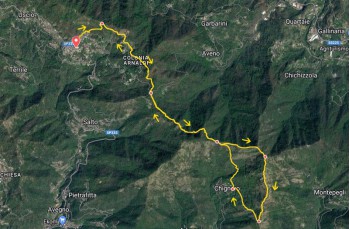
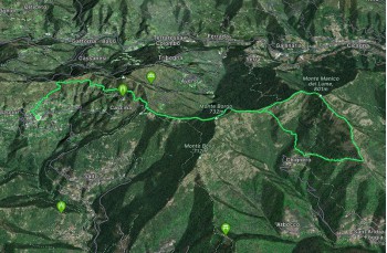
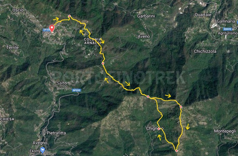
Trail ring Uscio - Manico del Lume - Chignero

Difficulty High
Duration 4h 50'
Length km. 13,000
Footpath Signs Due cerchi vuoti + Segnavia XX + Triangolo vuotoLinea rossa + tre pallini
Dislivello353m - 772m | dislivello positivo 861m | dislivello positivo 862m
PartenzaStarting point
Passing through

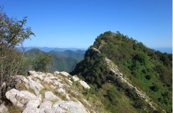
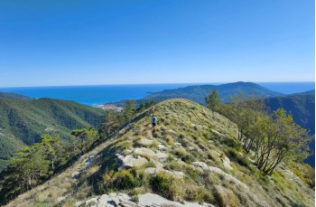
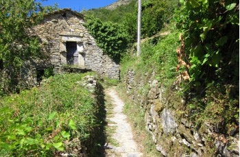
This itinerary is recommended for experienced hikers due to its length and some sections equipped with chains that require a lot of attention.
It is recommended to start with an ample supply of water as there are no water sources along the route.

The starting point is in Uscio, which can be reached in 15 minutes by car or bus from Recco. It is located near the Church Sant' Ambrogio, where you take Via Costa Chiesa on the left, which quickly ascends to Via Bisagno.
From there, you continue to the right and reach the trailhead at the beginning of Via Arnaldi. The trail starts to ascend through a beautiful chestnut forest, passing a few scattered houses, and becomes more open, eventually reaching Passo Casetti.

You cross the wooden bridge and continue on a flat path towards Passo della Spinarola, avoiding the trail that leads to Monte Tugio, and following the trail markers Due cerchi vuoti. After about 1.7 km of easy walking, you will reach Passo della Spinarola.

Descend and take the trail on the left, marked with Segnavia XX, direction Passo Serra. This part of the trail is exposed to the north, and in case of wet ground, some narrower sections can be a bit tricky. However, overall it is passable by paying the necessary attention, as always.

Upon reaching Passo Serra, which marks the transition into the municipality of Rapallo, you continue to the left, following the trail sign Triangolo vuoto, by ignoring the fork in the road that descends to Chignero and shortly after, the one on the left that descends to Serra village.

A steep but exhilarating ascent on large rocks leads to a power line tower, from where the destination starts to come into view. This is where the most challenging stretch begins, requiring a lot of caution, some experience, and suitable footwear.

To reach the summit, indeed, you have to tackle a few short sections, first downhill and then uphill, on rocks equipped with chains. It is not recommended to tackle this trail in wet conditions.

Upon reaching the Manico del Lume summit (801 meters above sea level), in addition to a spectacular view that extends from the Gulf of Tigullio to the inland areas, next to the cross, you can consult a panel from the CAI (Italian Alpine Club) that indicates the names of all the surrounding mountains.

The route continues with the trail that descends towards the south, entering the forest and shortly arriving in front of a rock that needs to be bypassed to continue straight, following the trail marker. Linea rossa (turning left leads in the direction of Monte Pegge), and ignoring the trail that descends to the right, which goes directly to Chignero.

You are now on what is commonly called the "bench trail": we recommend paying attention as some sections are a bit exposed and can be tricky if not approached with caution. Following the ridge, which offers scenic views, you continue to descend until you reach a large rock where you need to climb with the help of a chain.

Continuing on a terrain of rocks, accompanied by the scent of wild thyme, you descend and reach a group of rocks that need to be bypassed for a short distance, following a slightly exposed trail that requires a lot of attention, especially when the ground is wet as there is a risk of slipping. Once past this section, the descent becomes easier but still offers panoramic views. After approximately 1.2 km, the trail ends behind a wooden bench that overlooks Rapallo.

Turn right and descend towards Chignero, first crossing a grassy terrain and then a chestnut forest, with a final stretch characterized by gravel. After approximately 800 meters, following the same trail marker, you will reach the first houses of the small village.

A few meters before reaching the church of Chignero, you will cross paths with the trail to Passo Serra on the right tre pallini. You follow the trail and start ascending, continuing straight on the path. After passing a final dwelling, the path enters the woods and leads to a stream, which is usually dry. You cross the stream, reaching a first junction.

You turn right, following the clear signs to Passo Serra by FIE (Italian Hiking Federation). The path now consists of irregular stone staircases interrupted by some flat sections. Soon, the trail emerges from the forest and crosses a very open area, providing a panoramic view of the Portofino promontory and the surrounding valleys.
Following the well-marked path, finished with stones and without any difficulty, you reach the ridge, finding yourself once again in front of the rock encountered earlier, with all the indications clearly marked.

Here, you turn left to return to Passo Serra. By retracing the same path taken earlier, you will arrive at Passo della Spinarola, then Passo Casetti. Descending from there will lead you back to Uscio, the starting point, in front of the church.


Unlock view and download the trail track by purchasing a map.

The path tracked on Google Maps

Data sheet

Time
From 4h to 5h
Length Km
10 - 15
Difficulty
High
100% secure payments