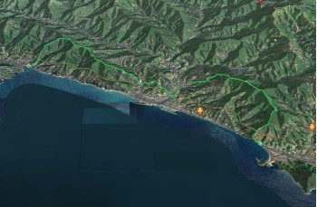
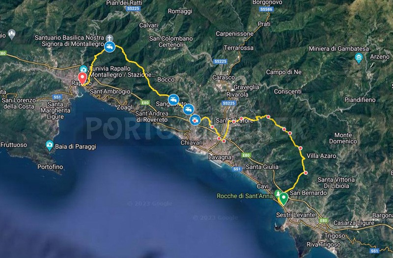
Difficulty | Medium - High |
Duration | 8h 45' |
Length Km | 29,200 |
Footpath signs | ![]() ![]() ![]() ![]() ![]() ![]() ![]() ![]() ![]() ![]() |
![]() ![]() ![]() | |
![]() |
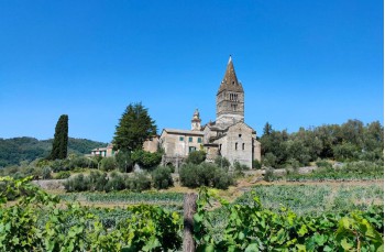
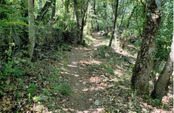
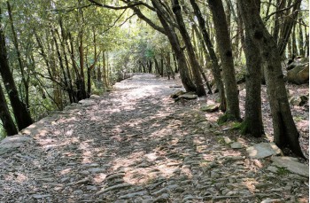
We propose here a walking itinerary that starts from Sestri Levante, crosses the hilly trails, and arrives in Rapallo.
Until San Salvatore dei Fieschi, there are no water sources, so it is advisable to start with an adequate supply of water.
The starting point is at the end of Via Antica Romana Occidentale, near the campsite where the two paths that lead to Rocche di Sant’Anna begin.
We recommend paying attention because these paths are also used by mountain bikers (MTB).
Take the one on the left, steeper but faster, which, in about 15 minutes, reaches a junction; for those who have never seen the ruins of the church of Sant’Anna, it is recommended to make the very short detour to the left to reach them; otherwise, after stopping to admire the magnificent panorama that embraces Sestri Levante and the entire Gulf of Tigullio, continue on the path that goes up on the right.
In this stretch of the path, the footpash signs are varied; the official FIE markers should be and
, but even if faded, the CAI trail marker is also present
.
In any case, there is no way to go wrong; by always going straight on the rocky path, initially more open and shaded in the final part, you will reach Monte Costello (498m above sea level) in just over an hour.
Continuing in the same direction, you exit the forest, and by passing a house, you reach a dirt road that you must follow to the right, towards Capenardo, to reach a panoramic point, where there is also a table with benches, in the locality named Selva.
Here, the directions are very clear, and after a flat stretch, you start climbing again to reach the summit of Monte Capenardo (690m above sea level), which, surrounded by vegetation, does not offer any viewpoint. But immediately after, following the ridge, you are rewarded with a spectacular view of the lower Lavagna and Chiavari up to Promontorio di Portofino, which leads to Monte Rocchette (700m above sea level).
With a series of ups and downs, after passing a slate-made structure where you can have fun recognizing the surrounding mountains, as well as contemplating the sea of the Gulf of Tigullio, the path enters the forest, passing by two open-pit quarries, unfortunately covered by vegetation, to end up on a dirt road, in the locality San Giacomo.
Here, you reach the little church to take the path that descends to the left into the forest, marked with 10a. It is the “Via dell’ardesia”, the path that women often walked, sometimes barefoot, to bring slate slabs from the quarries to the sea.
As you descend, the path leaves the forest to cross the countryside, passing by some houses and occasionally intersecting the dirt road. In just under an hour, you will arrive at San Salvatore di Cogorno, in front of the magnificent Basilica dei Fieschi built in Gothic style in the 1200s.
In the town center, there are bars and shops for a possible supply of water or food.
Now crossing the village on Via Bertulla and then Via alla Basilica, we reach a passage that, along the gardens and a stream, leads to Via Lungo Entella.
Here, there is a drinking water tap.
Continue towards the sea on this beautiful pedestrian and bicycle path for about 1.5 km, until you spot the uphill path to the Maddalena Bridge on the left.
With great care (there is no sidewalk), walk to the left, towards Chiavari.
Keep going straight, past the roundabout, and continue to the right on Via Piacenza until you reach the underpass of the highway.
We are in the locality Rì Basso where a signpost pole on the left directs you to a steep uphill path, which, in about twenty minutes, following the trail markers, allows you to reach the church of San Michele di Rì Alto, one of the oldest churches in Chiavari with a beautiful square offering remarkable views.
After the recommended break, return to Via San Michele and follow it to the end to meet the paved road that you should follow uphill for about 100 meters, arriving at locality Vicinale della piccettina, as indicated by the sign. Here, go left, always straight, and at a fork in the road, the municipal locality of La Rissa, follow the trail marker leading downhill among houses and terraces, ending up in San Pier di Canne in the commercial area.
After crossing the small square, enter Via San Rufino, where you can find a drinking water tap.
After a few meters in the direction of the sea, near the Parish, turn right onto Via Maixena, a paved road where you will find two trail markers and
which you should follow for 200 meters before leaving it when, on the right among the houses, you spot some signs: Le 5 torri; Sentiero Liguria.
This is a staircase that becomes a path after a little over 200 meters, climbing with a certain slope and soon reaching the churchyard of San Martino di Maxena.
Here, there is a drinking water tap.
Continue uphill, keeping to the right of the cemetery, to cross a countryside area offering some panoramic views of the Gulf of Tigullio before entering a beautiful forest that provides some flatter sections and, in the summer, some coolness.
After passing through a small group of houses in locality Costa, where there is a drinking water tap on the right, you reach a fork in the road in Vicinale di Costa Campodonico.
Here, continue to follow to continue gaining altitude, walking through the woods and passing by Baita Facciu, a small wooden hut made available by a private individual, very useful for finding shelter in case of rain or simply to rest before continuing.
At the first junction, keep right, following the same trail marker, and after just over 30 minutes on the paved road downhill, you will reach Passo dell’ Anchetta, a point where the spectacular view demands a stop and where you will also find a trattoria.
Continue on the road until an obvious sign and FIE trail markers on the wall indicate that you must leave the asphalt road to tackle the challenging final uphill stretch of our itinerary.
This is a tiring ascent, especially at this point in the journey, but it is short and entirely in the woods. After passing "U Casun du Giamin," a well-renovated rustic stone building, it gives way to a descent to the votive shrine at Passo della Colla.
From here, walking mostly on flat terrain with some minor ups and downs and accompanied by views of Zoagli and the Promontorio di Portofino, you arrive at the foothills of Monte Castello, which you skirt to the right to join the trail coming from Sant’ Ambrogio and continue right towards Montallegro.
Now the path is all flat on a beautiful shaded trail of holm oaks. After passing by a restaurant hotel, you reach the rear of Santuario di Montallegro.
In Montallegro, besides a drinking water tap next to the church, you can use the services of three bars and public bathrooms (at the bottom of the Sanctuary staircase and behind the Cable Car Bar). From the churchyard, descend towards the cable car station and follow the mule track down to Rapallo.
This is a cobbled path that, after a flat section, descends with some switchbacks, alternating between stretches in the woods and more open sections, eventually reaching the paved road in Il Pellegrino after about 30 minutes.
Here, after a few meters to the left, turn right and resume the path that descends among the houses, passing by the charming church of San Bartolomeo, approaching the town center of Rapallo and ending on Via Don Minzoni first, and then on Via San Francesco, where the itinerary concludes.
The path tracked tracciato by GPS
Unlock, view and download the gpx track by becoming a Supporter.
Data sheet
- Time
- More than 7h
- Length Km
- More than 20
- Difficulty
- Medium - High