San Fruttuoso di Camogli - Base 0 - Pietre Strette
  • San Fruttuoso di Camogli - Base 0 - Pietre Strette
  • Trekking from San Fruttuoso of Camogli to the summit of Monte di Portofino
  • Trekking from San Fruttuoso of Camogli to the summit of Monte di Portofino
  • Trekking from San Fruttuoso of Camogli to the summit of Monte di Portofino Available with Supporter
  • Trekking from San Fruttuoso of Camogli to the summit of Monte di Portofino Available with Supporter
  • Trekking from San Fruttuoso of Camogli to the summit of Monte di Portofino Available with Supporter
  • Trekking from San Fruttuoso of Camogli to the summit of Monte di Portofino Available with Supporter
  • Trekking from San Fruttuoso of Camogli to the summit of Monte di Portofino Available with Supporter
  • Trekking from San Fruttuoso of Camogli to the summit of Monte di Portofino Available with Supporter
  • Trekking from San Fruttuoso of Camogli to the summit of Monte di Portofino Available with Supporter
  • Trekking from San Fruttuoso of Camogli to the summit of Monte di Portofino Available with Supporter
  • Trekking from San Fruttuoso of Camogli to the summit of Monte di Portofino Available with Supporter
  • Trekking from San Fruttuoso of Camogli to the summit of Monte di Portofino Available with Supporter
Difficulty Moderate
Duration 2h 00m
Distance 3,300
Trail marker 2-pallini.png + triangolo.png + segnavia
Starting point San Fruttuoso di Camogli

Trail effort

Shows the overall physical effort required by the route, not the technical difficulty of the trail.

Supporter

With Supporter, you can view the real trail effort.

Supporter

Route profile

Use the trail on the go

Open the trail on your phone or download the file to use it during your hike.

Open Google Maps Supporter Download GPX Supporter Download PDF Supporter+
3D route animation Supporter+
  • Interactive map
  • Synced elevation profile
  • GPX
  • Key waypoints
  • Planning tools

Unlock the complete trail features

With Supporter+, you unlock the interactive map, synced elevation profile, GPX, key waypoints and a more useful trail view.

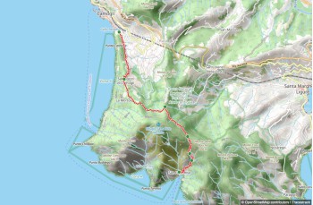
This trail offers an alternative to the direct route through Casella, leading to the summit of Monte di Portofino and onward to other destinations in the area.

Start on the small road behind the Abbey, passing under Torre Doria to reach a small pebble beach, then continue through the fishermen's houses.
Upon reaching the helicopter landing pad, climb the steep and uneven path into the shaded forest, offering panoramic views of the bay as you gradually ascend.

After about 40 minutes, you'll reach a rest area with wooden tables and benches at Base 0 (220 meters above sea level). We recommend a short detour to enjoy the sea view from the terrace, accessible via the path behind the large rock.

Back on the main trail, leave the sea behind and turn left (right leads to Portofino mare) to continue on the scenic dirt path surrounded by lush vegetation.
Ignore any side paths along the way: at Costa dei Ghidelli, there's a connection to the trail from San Fruttuoso that leads directly to Pietre Strette; at Ghidelli, you can reconnect to the Portofino summit-Portofino mare trail.

When you reach Felciara, marked by numerous ferns, head right towards Bocche if you wish to end your hike in Santa Margherita Ligure (check the map), or continue with us towards Pietre Strette.
The trail, offering occasional sea views, now levels out and soon joins the path from Portofino mare.
In a few more minutes, you'll arrive at Pietre Strette, a rest area equipped with benches, wooden tables, and a drinking water tap.

From here, you can reach various destinations, including Camogli, San Rocco di Camogli, and Ruta.

You might also like