San Fruttuoso di Camogli - San Rocco di Camogli
  • San Fruttuoso di Camogli - San Rocco di Camogli
  • Pranoramic trail from San Fruttuoso to Camogli
  • Pranoramic trail from San Fruttuoso to Camogli
  • Pranoramic trail from San Fruttuoso to Camogli Available with Supporter
  • Pranoramic trail from San Fruttuoso to Camogli Available with Supporter
  • Pranoramic trail from San Fruttuoso to Camogli Available with Supporter
  • Pranoramic trail from San Fruttuoso to Camogli Available with Supporter
  • Pranoramic trail from San Fruttuoso to Camogli Available with Supporter
  • Pranoramic trail from San Fruttuoso to Camogli Available with Supporter
  • Pranoramic trail from San Fruttuoso to Camogli Available with Supporter
  • Pranoramic trail from San Fruttuoso to Camogli Available with Supporter
  • Pranoramic trail from San Fruttuoso to Camogli Available with Supporter
  • Pranoramic trail from San Fruttuoso to Camogli Available with Supporter
  • Pranoramic trail from San Fruttuoso to Camogli Available with Supporter
  • Pranoramic trail from San Fruttuoso to Camogli Available with Supporter
  • Pranoramic trail from San Fruttuoso to Camogli Available with Supporter
  • Pranoramic trail from San Fruttuoso to Camogli Available with Supporter

WarningWARNING!

ORDER FOR TEMPORARY CLOSURE OF "PASSO DEL BACIO" TRAIL.
With orders from the Mayor of Camogli no. 89 of May 29, 2024, and no. 91 of May 30, 2024, pedestrian traffic is prohibited in both directions on the trail known as "Passo del Bacio" between the locations Batterie and Costa del Termine.

Difficulty Moderately difficult
Duration 4h 00m
Distance 6,400
Trail marker Due pallini
Starting point San Fruttuoso

Trail effort

Shows the overall physical effort required by the route, not the technical difficulty of the trail.

Supporter

With Supporter, you can view the real trail effort.

Supporter

Route profile

Use the trail on the go

Open the trail on your phone or download the file to use it during your hike.

Open Google Maps Supporter Download GPX Supporter Download PDF Supporter+
3D route animation Supporter+
  • Interactive map
  • Synced elevation profile
  • GPX
  • Key waypoints
  • Planning tools

Unlock the complete trail features

With Supporter+, you unlock the interactive map, synced elevation profile, GPX, key waypoints and a more useful trail view.

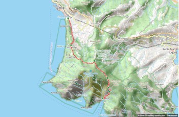
This trail from San Fruttuoso to San Rocco di Camogli is, in our view, the most stunning in the Portofino Park, but it's also quite demanding. Expect steep climbs and sections on cliffs above the sea. Carry plenty of water, as there are no sources along the way. Be aware that some parts are very exposed to the sun.

The hike starts at the pier, across from the abbey. Climb the stone steps and continue through a series of switchbacks in a forest, where you'll see magnificent ancient pines. In about 30 minutes, you'll reach the Valico della Costa del Termine (257 m above sea level), near Punta Torretta.

From here, descend steeply (watch for slippery leaves) into a shady valley, leading to a viewpoint above Cala dell'Oro, a beautiful bay where access is prohibited. After crossing a dry stream (in summer), you enter the most spectacular part of the trail, where the promontory's rocks plunge into the deep blue sea, creating a unique natural scene.

The path, sometimes narrow and uneven, is rated "very challenging" due to short sections (one in particular with few footholds) on cliffs above the sea. Chains help with these passages, but it's STILL crucial to wear proper footwear and be very cautious. Not recommended for those with vertigo.

The view of Punta Chiappa below signals your approach to Batterie (246 m above sea level), a viewpoint named after World War II bunkers.

Leave the coast and head into the woods, navigating some ups and downs, followed by a gentle slope to Fornelli (238 m above sea level). Here, the trail joins another from Toca (and Pietre Strette) and continues smoothly through increasingly tended lands as you near the first houses.

Pass through the small village of Mortola, and continue straight, ignoring the left turn to Punta Chiappa, along the "sea view" path to the scenic churchyard of San Rocco di Camogli (here you'll find a drinking water tap, as well as shops and bars).

San Rocco di Camogli is connected to other locations by bus. You can also walk down to Camogli in about 20 minutes.

You might also like