- Out-of-Stock
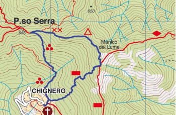
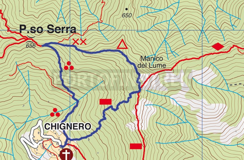
Circular trail Chignero - Passo Serra - Manico del Lume


| Difficulty | High |
| Duration | 2h 40' |
| Length Km | 3,100 |
| Footpath signs | |
We present you a circular itinerary from Chignero, a small village 5 km from the Rapallo motorway exit, which we recommend to do on clear days, possibly starting in the morning, to fully enjoy the incredible panorama.
The last part of the trail before reaching the summit is classified as EE (for expert hikers) due to the presence of some passages equipped with chains: great care and hiking shoes are required.
Chignero can be reached following the road to San Pietro di Novella, after passing the Hospital proceeed ahead for 5 kms passing through "Sant'Andrea di Foggia" and than you'll reach the end of the carriage road near the Chignero's church (next to the private car parks, there are are some others free). The alternative is to use the buses (see here the timetables before leaving because there are not many trips and on Sundays they are only on request).
On the left of the church, take the private asphalt road turning on the left after few meter following ![]() and after 10 meters
and after 10 meters![]() .
.
After passing a nice stone cottage, the path climbs narrow between shrubs on one side and dry stone walls on the other.
Continue straight on the path which, after passing a last house, sneaks into the woods to lead you to a small wooden bridge that you have to cross, arriving shortly after at a first crossroads. Turn right following the clear signs for P.so Serra. Now the route consists of irregular stone steps interrupted by some flat sections.
The path soon exits the wood to cross a very open area that offers a panoramic view of the Portofino promontory and the surrounding valleys. Walking along the well marked path finished with stones, without any difficulty you find yourself on the ridge, from where you can also see the Val Fontanabuona.
Continue straight and after passing last house, the trail continues into the woods to lead you to a small wooden bridge that you cross to reach the first crossroads. Turn right and follow the signs to clear P.so Serra. Now the path is made up of irregular stone steps interspersed with a few flat stretches.
In short, the trail leaves the woods to cross a very open area that offers a panoramic view from the promontory of Portofino and the surrounding valleys. Along the well marked path finished in stone, without any difficulty, you find yourself on the ridge, where you can admire the Fontanabuona Valley.
When you reach a fork in the road, continue to the right on the uphill path indicated by XX and ![]() which leads you, for a very short stretch in the woods. After 100 meters, you have to leave the XX to follow the
which leads you, for a very short stretch in the woods. After 100 meters, you have to leave the XX to follow the ![]() that takes you back to the crest of the mountain.
that takes you back to the crest of the mountain.
A steep but exciting climb leads to a pylon of light by which you begin to see the destination. From here the path became most challenging, but surmountable with a minimum of care. In fact, to reach the summit you have to overcome a few short steps, first downhill and then uphill on rocks partly aided with chains. On top of the Manico del Lume there are, in addition to a 360 degree view, a cross and a panel placed by CAI which indicates the names of all the surrounding mountains.
For the return, you must take the path on the opposite side of the cross, which initially has two trail markers: ![]() and
and ![]() .
.
At the fork, following the directions on the "Chignero-direttissima" sign, continue to the right. The trail marker ![]() is not very frequent, but some ribbons tied to trees and paint markings guide you easily along the descent.
is not very frequent, but some ribbons tied to trees and paint markings guide you easily along the descent.
The path initially descends through the forest and then crosses some sections surrounded by ferns and brambles, which could hinder passage during the warmer months.
The descent continues with the most interesting part: you walk along some sections of ancient stone stairways that once connected the village houses, of which a few stone ruins still remain.
A few meters after the last rustic house, which has been restored and is inhabited, you will find yourself back on the outbound path, above the church of Chignero.
Unlock, view and download the gpx track by becoming a Supporter.
Data sheet
| Difficulty | High |
| Duration | 2h 40' |
| Length Km | 3,100 |
| Footpath signs | |