- Out-of-Stock
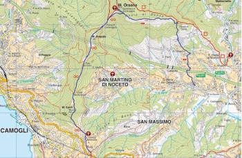
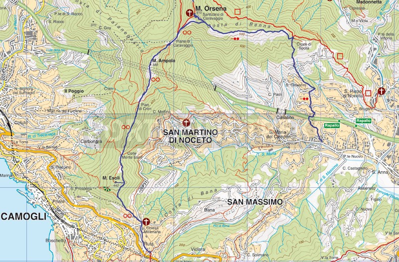
Rapallo - Santuario di Caravaggio - Ruta di Camogli


| Difficulty | Medium |
| Duration | 3h 00' |
| Length Km | 7,200 |
| Footpath signs | |
The starting point of this excursion is in Via San Tomaso in Santa Maria del Campo (a small hamlet of Rapallo easily reachable also by bus). It is recommended to have a good supply of water because along the way there are neither sources nor taps of drinking water.
Following the signs, take Via San Tomaso and follow it for about 300 meters until you will find on the left a stone staircase that leads to the “ Ruins of San Tomaso” (12th century). Here continue on the road in front of the site that passes over the highway, then turn right to reach the path that climbs between peasant houses and typical Ligurian cultivated fields named "Fasce".
The path going up crosses the carriage road in some places; you always continue straight along the "creuze", always marked by ![]() , up to the locality named "Spotà" , where a road bar delimits a private property.
, up to the locality named "Spotà" , where a road bar delimits a private property.
On the left you will find a well-maintained staircase that climbs between beautiful villas with gardens and reaches a final stretch of paved road. Here you have to continue on the steep staircase, made up of narrow and irregular steps which goes into the woods reaching a detour.
Both paths lead to the Caravaggio Sanctuary, but we recommend choosing the path on the left which is the one regularly signposted and is more accessible passing close by the “ Croce di Spotà ”.
As you climb the route becomes less steep and offers splendid views over the valley. The path now continues on a false level, surrounded by shrubs, and reaches the helicopter landing pad.
At this point, with a last effort, walk the 136 steps which separate you from the Sanctuary (615 meters above sea level), you will be rewarded by a priceless panorama.
Go down the staircase you have just traveled down again and when on the elicopter pad, take the path to the right, a wide and easy path in stone and concrete marked with three red dots.
At the first fork, continue to the left; hence the signal to follow is ![]()
![]() . At a first plain stretch, where on the right you will notice a shack used as a refuge, you will find a large lawn, a very popular destination for picnics.
. At a first plain stretch, where on the right you will notice a shack used as a refuge, you will find a large lawn, a very popular destination for picnics.
At this point we suggest to abandoning the main path (which always continues straight and well marked), following a path which a bit longer, but certainly much more panoramic. Climb up, the hill is not so hard, you will find a narrow but clean path that climbs through thick vegetation to reach a repeater from which you can enjoy a very wide 360° view over the entire valley. Follow the path of earth and stones that descends quite steeply along the ridge, among fragrant wild thyme plants, and observe Rapallo on your left and Recco on the right.
At a boar hunting post, the alternative route is it rejoins the main path arriving at another fork from which you must always proceed straight.
The path descends shaded with a series of stone steps crossing another panoramic point to arrive at a meadow which in spring turns into a carpet of primroses and violets.
Continue on a descent which begins surrounded by the bush and continuing, as you get closer to the houses, between strips and dry stone walls and ending in Via Caravaggio, next to the Millenary church of Ruta di Camogli.
*It will be possible to comeback to Rapallo by bus. Checking the schedule of these two lines "Rapallo-San Martino di Noceto-Ruta" or "Rapallo-Ruta-Recco".
Unlock, view and download the gpx track by becoming a Supporter.
Data sheet
| Difficulty | Medium |
| Duration | 3h 00' |
| Length Km | 7,200 |
| Footpath signs | |