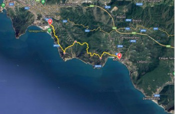
Trail Moneglia - Riva Trigoso


| Difficulty | Low |
| Duration | 3h 00' |
| Length km. | 9,000 |
| Footpath signs | |
This is a trail that connects the two renowned seaside resorts of the Eastern Ligurian Riviera, through scenic hillside trails.
Along way there stock up water
Starting from the coast of Moneglia, you move to the historic center following the central Via Craveri, then turning left onto Piazza Fabio Marengo and continuing on Via Roma.
In a few minutes, you'll reach the Parish Church of San Giorgio with the bell tower decorated with typical black and white stripes, and the adjacent Abbey of the same name, now converted into accommodation like the Monleone Fortress, built in 1100 for defensive purposes, which you pass by shortly after climbing the staircase on the left.
Now continue on Via Venino, an asphalted road that steeply ascends to the Case Venino hamlet, an area where some scattered villas stand; in this stretch, you can see the FIE trail markers ![]() .
.
At the end of the road, a signboard illustrates the trail network with various possible routes.
With a short stretch ascending among rocky and uneven terrain, you enter the holm oak forest, reaching a junction where you turn left following the trail marker ![]() leading to a flat and panoramic path, with a spectacular view of the Gulf of Tigullio.
leading to a flat and panoramic path, with a spectacular view of the Gulf of Tigullio.
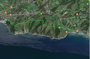
You are now on the Blue Green Trail, the mid-hillside path that connects the main villages of the Eastern Riviera.
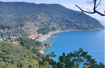
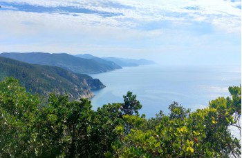
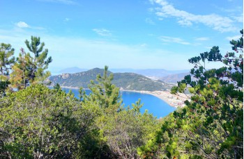
Continuing for a long stretch on a flat path, with some gentle ups and downs that pose no difficulty, you find yourself immersed in an extraordinary scenario. The trail advances straight through the typical Mediterranean vegetation, offering panoramic views of Riva Trigoso, Sestri Levante, the Portofino Promontory on one side, and Punta Mesco on the other side.
After about 2 km, you reach a junction in the locality of Colle del Lago, where a table with wooden benches has been set up, a less crowded rest area than the next one.
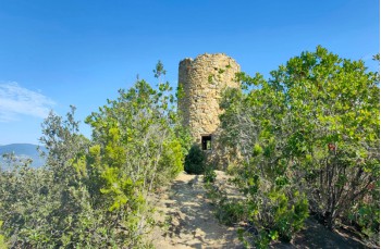
Here, still following the same trail marker ![]() , you descend to the left towards Torre Punta Baffe where, in the 16th century, the Republic of Genoa built the Tower of Punta Baffe, along with other towers erected on the main promontories of the Eastern Ligurian Riviera for defensive purposes.
, you descend to the left towards Torre Punta Baffe where, in the 16th century, the Republic of Genoa built the Tower of Punta Baffe, along with other towers erected on the main promontories of the Eastern Ligurian Riviera for defensive purposes.
Today, the small fortress is used as a bivouac and a rest area.
Following the directions and the trail marker ![]() , you return to the main path, which with a continuous slight descent heads towards Riva Trigoso, recognizable in the distance with its shipyards.
, you return to the main path, which with a continuous slight descent heads towards Riva Trigoso, recognizable in the distance with its shipyards.
Along this last part of the route, benches have been placed at strategic points to contemplate the panorama.
The trail reaches a dirt road that descends in switchbacks until it becomes an asphalted road that ends on Provincial Road 370, in front of the bocce court of Riva Trigoso.
Turn left to reach the village city center, where there are bars, restaurants, and shops. Proceeding to the right, you'll reach the train station to return, to Moneglia, if necessary.
Unlock, view and download the gpx track by becoming a Supporter.
Data sheet

| Difficulty | Low |
| Duration | 3h 00' |
| Length km. | 9,000 |
| Footpath signs | |