- Out-of-Stock
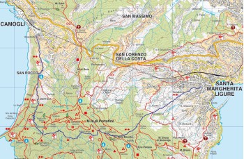
Camogli - San Rocco - Pietre strette - S. Margherita Ligure


| Difficulty | Medium |
| Duration | 2h 40' |
| Length km. | 6,980 |
| Footpath signs | |
You can support us by becoming one of our Supporters.
A great little help that will allow you to access all the contents of the site.
Are you already Supporter?
Log in now
An itinerary that connects two renowned destinations on the Ligurian Riviera: Camogli and Santa Margherita Ligure.
The route begins near the parking area in Camogli, along Via San Bartolomeo, the road that passes under the Carabinieri barracks and runs alongside the stream.
A footpath, consisting of approximately 800 steps, ascends amidst cultivated terraces and dry stone walls, passing through some houses and...
You can support us by becoming one of our Supporters.
A great little help that will allow you to access all the contents of the site.
Are you already Supporter?
Log in now
You might also be interested in

| Difficulty | Medium |
| Duration | 2h 40' |
| Length km. | 6,980 |
| Footpath signs | |