Support portofinotrek and unlock all features.
search
  • Support portofinotrek and unlock all features.
  • Support portofinotrek and unlock all features.

Ready-to-use maps and routes

Choose your plan in the “Choose plan” menu

Two levels, one product:
Supporter → to explore and understand routes
Supporter+ → to actually use them on the field

12-month access, no automatic renewal.

Supporter includes:
  • Complete descriptions + technical data
  • Google digital map with trails mapped by PortofinoTrek
  • Starting point directions + favourites
  • Downloadable GPX files
  • To explore routes before starting
  • Does not include advanced tools (planner, interactive map)
Supporter+ adds: Tailored
  • Custom itinerary (time, level, weather, logistics)
  • Navigation on Google Maps
  • GPX download for offline use
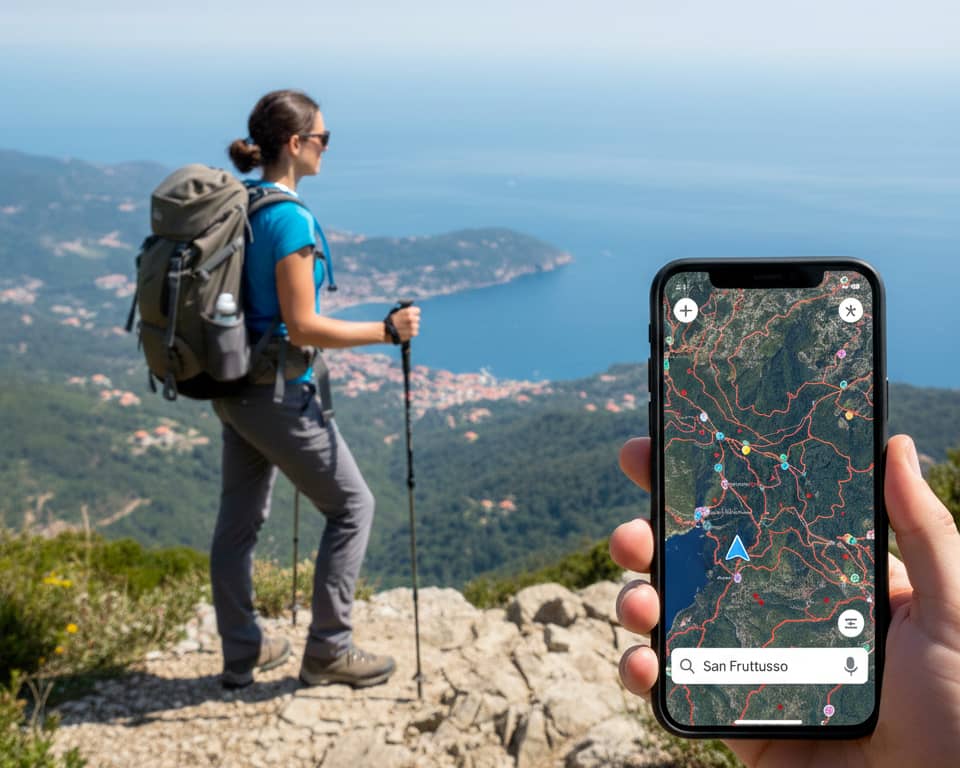
  • Interactive map + elevation profile
  • Planner to create custom routes (included, subject to fair use)
  • Ready-to-use PDFs for preparation
Choose plan: Supporter
€20.00
Tax included

Enter the email linked to your Google account to access the reserved map.

🔒 Personal access, not shareable

The second address will receive access directly through Google.

Quantity

Walk with the right information.

Hiking routes in the Portofino Park, Tigullio Gulf, Golfo Paradiso and surrounding inland areas.

PortofinoTrek was created to help people who love hiking, without needing to be experts in trails or maps. Here you’ll find carefully selected routes, explained in a simple way, focusing on what really matters: where to start, what to expect, how challenging it is, and whether it’s right for you.

A local project, built on the territory. No “brochure-style” slogans — just useful information, like we would share with a friend.

What you get as a Supporter

Content and tools to explore independently, with clear and reliable information.

  • Google digital map with trails mapped by our team.
  • Complete descriptions + technical data.
  • Starting point directions + favourites.
  • Downloadable GPX files for offline use.

- Everything you need to understand the route before starting

Email: used to share access to the Google map. (A Gmail account is required to access the map)

The digital map with over 3,000 km of trails.

It’s a navigable map based on Google Maps: you can zoom, follow the route, see intersections and orient yourself even if you’re not familiar with maps. The trails are mapped and verified by the PortofinoTrek team

.
  • Clearly highlighted routes
  • Visible intersections and useful points
  • Satellite view + map: understand where you are

In short: the easiest way to follow a route without complex tools.

Supporter+: when you want to truly use it

Not just understanding the route, but following it step by step.

  • Open the trail directly in Google Maps on your phone
  • Download the GPX and use it offline in your apps
  • Interactive map with synced elevation profile
  • Planner to create custom itineraries (included, subject to fair use)
  • Ready-to-use PDFs for preparation

In short: you're already using PortofinoTrek at its best.
With Supporter+, you take it to the next level.

Quick plan comparison

Free

To explore

  • Ad-free navigation
  • GPX downloads
  • Digital map
  • Full descriptions + technical data
  • Favourites
  • Custom itinerary

Supporter Recommended

Full content

  • Ad-free navigation
  • Digital map
  • Full descriptions + technical data
  • Favourites
  • GPX downloads
  • Custom itinerary

Supporter+

Tools + real usage

  • Everything in Supporter
  • Planner (fair use)
  • Interactive map
  • PDFs
  • Full on-field usage

Want the full details? See the “Compare plans” page.

How it works

1) Choose your plan
Supporter or Supporter+
2) Enter your email
It is used to share access to the Google digital map. (A Gmail account is required to access the map)
3) Use the content whenever you want
Access for 12 months, ad-free and with no automatic renewal.

Quick questions

Do I need trekking experience?

No. The content is designed for beginners: simple explanations, practical guidance and clearly explained difficulty levels.

Is Supporter+ a guide service?

No. It provides planning and support (itinerary, timing, logistics, alternatives), not physical guiding.

Do GPX files work offline?

Yes. You can download them and use them offline with most navigation apps.

Is the planner included in Supporter?

No. The planner is available only with Supporter+ and is included with fair use limits.

Is ad-free navigation included in Free?

Yes. PortofinoTrek stays clean and lightweight for everyone: paid plans unlock content, tools and support.

Can I use routes offline?

Yes. You can download GPX files and use them offline in navigation apps.

Why we ask for support

PortofinoTrek is an independent project, built locally with time and passion. Support helps us keep content updated, test new routes and improve maps and descriptions, without turning the site into an advertising platform.

If you find it useful, Supporter is the simplest way to support the project.

If you find PortofinoTrek useful, becoming a Supporter is the simplest way to support it.

If you want to truly use the routes on the field, choose Supporter+.

You might also like