- Out-of-Stock
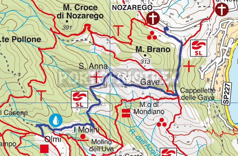
Nozarego - Cappelletta della Gave - Olmi


| Difficulty | Low |
| Duration | 40' |
| Length Km | 2,570 |
| Footpath signs | |
In addition to being a pleasant walk suitable for everyone, this trail offers numerous opportunities to continue towards other locations in Monte di Portofino, including embarking on more challenging routes.
Arriving at Nozarego, either by car (parking is available along the road), by bus, or on foot from Santa Margherita Ligure, you need to take the uphill path near the parish church, at the bus stop. The trail, initially surrounded by shrubs, then proceeds amidst terraced fields and passes by some villas with sea-view gardens, eventually merging with another path coming from Nozarego.
Following a flatter and more panoramic stretch, from which you can observe Punta Pedale, the Abbey of Cervara, and the entire Gulf, you reach the Gave area where a small chapel stands. At this crossroads (a descent to Paraggi on the left, and a woodland path to Crocetta on the right), beneath the little church, there's a tap for drinking water.
Continuing along the shaded, paved ascent, you cross cultivated fields, rural dwellings, and a tiny chapel (offering a lovely view) until you reach the location known as Mulini. Here, you encounter a rest area equipped with tables, benches, and drinking water, as well as the Mulino del Gassetta, a refreshment point and eco-museum. You'll also notice the detour to Crocetta (a location along the path from Portofino summit to Portofino sea).
After passing the beautifully restored mill, a very short and steep descent leads to the road (on the left, the Valle dei Mulini begins). Now a drivable route, it joins with the path coming from Portofino summit and leading to the sea. This meeting point is precisely the Olmi area.
Unlock, view and download the gpx track by becoming a Supporter.
Data sheet
You might also be interested in
| Difficulty | Low |
| Duration | 40' |
| Length Km | 2,570 |
| Footpath signs | |
